About
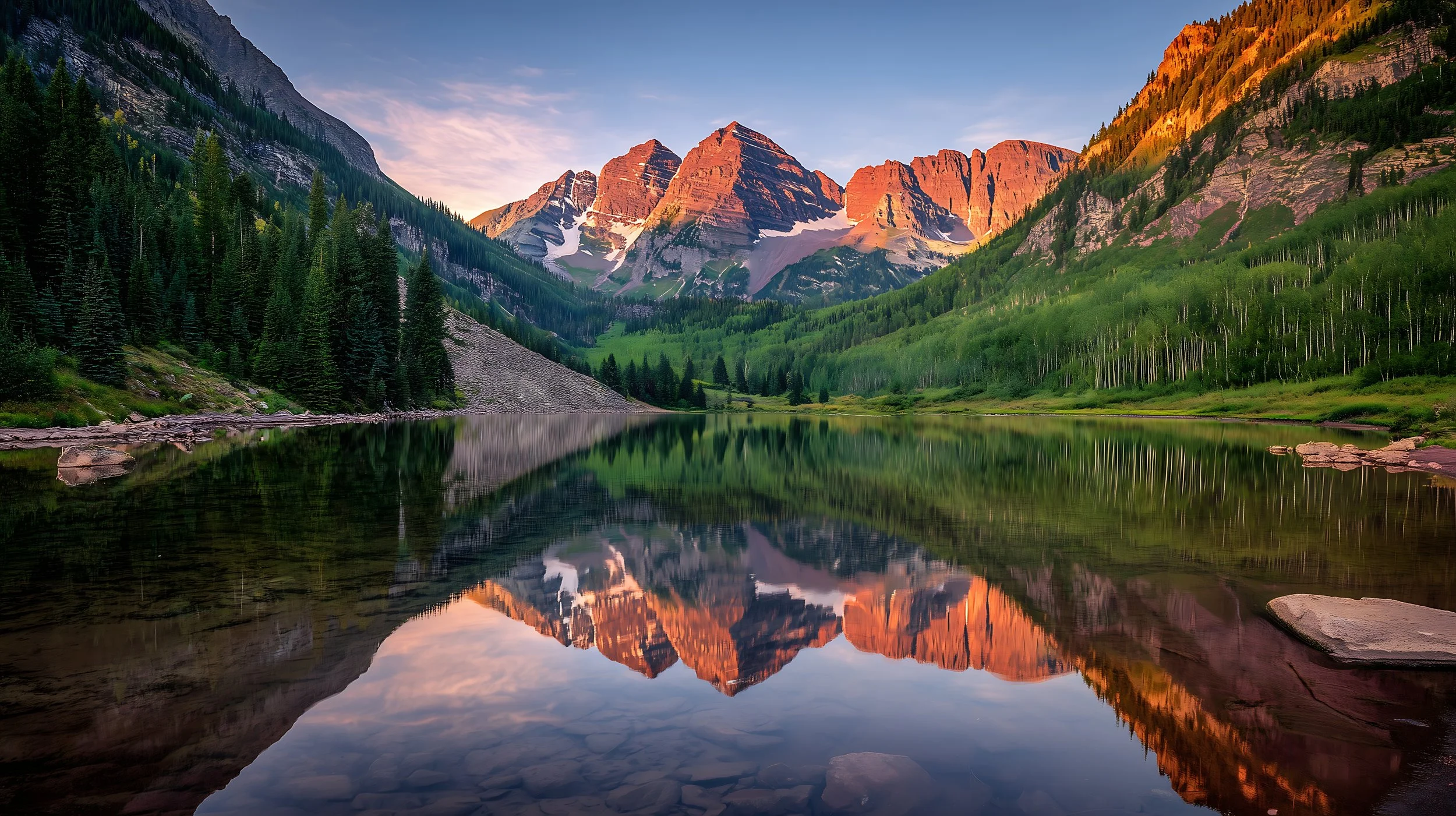
Mount Wilson and the El Diente Traverse, Lizard Head Wilderness
The Great Colorado Route’s design is guided by three primary objectives: beauty, breadth, and epicness. The route traverses as much of Colorado’s public lands and iconic destinations as logistically feasible for a thru hiker within a single season. It is also organized into logical segments, allowing hikers to experience the route piece by piece as a long-term section-hiking project.
Much like other long trails, the GCR is a mosaic of existing trails and high routes. While at first glance it may appear inefficiently routed, the beauty-first GCR is designed to maximize views. It deliberately takes the “path less traveled” to connect several of Colorado’s most treasured and hidden gems.
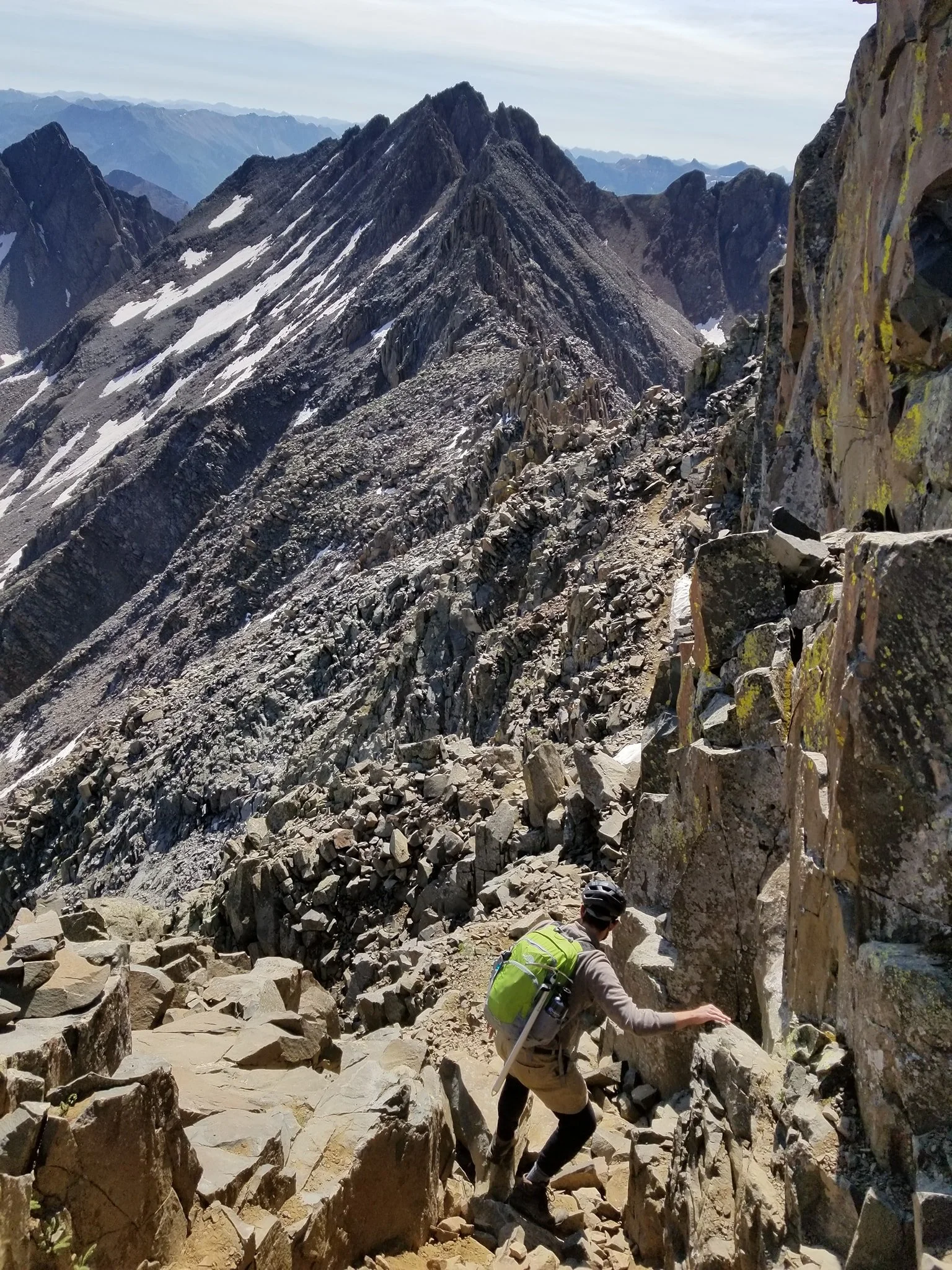
Hikers can expect route finding, scrambling along technical terrain (no special equipment required, other than perhaps a helmet), and breathtaking exposure scattered across the state. Lower-difficulty alternates, bad-weather bypasses, and shortcuts are provided where expedient, but the core route is designed with only the most adventurous and self-sufficient in mind.
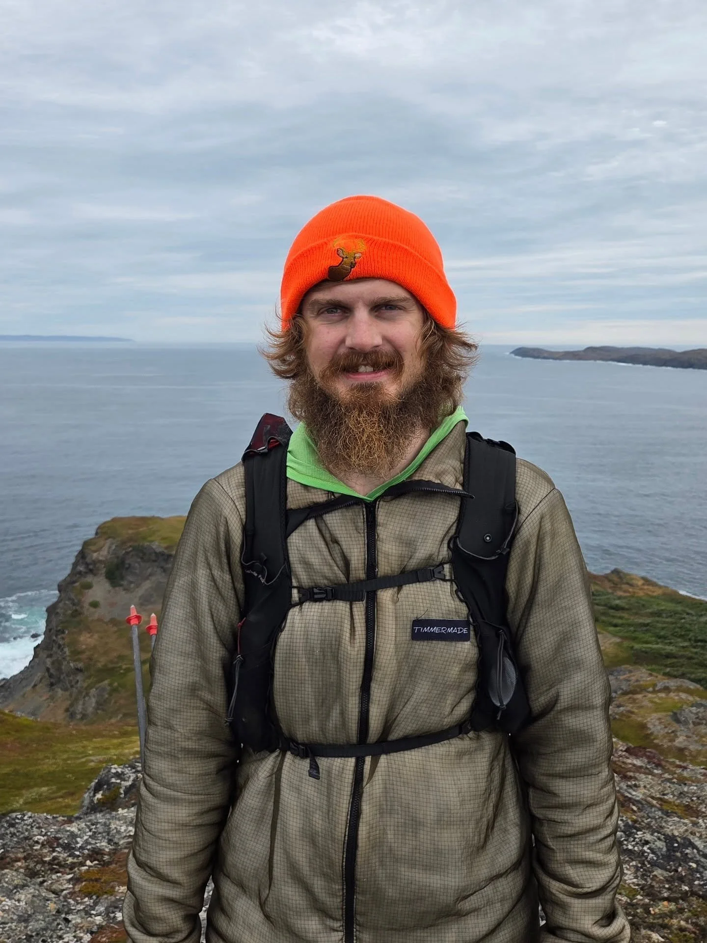
Donovan “Iceman” Rice at the northern terminus of the 5700-mile Eastern Continental Trail near L’Anse aux Meadows, NL, Canada
The GCR was envisioned by and is currently spearheaded by Colorado native and avid thru hiker Donovan “Iceman” Rice. Having spent most of his life in Colorado, completed all of the state’s 14ers, and finished the CDT in addition to other major thru hikes, he couldn’t help but envision a route that links Colorado’s most beautiful hiking destinations in a continuous footpath.
Never intended to replace or compete with other long-distance trails in Colorado, the GCR instead offers hikers a deeper exploration of the state, highlighting several of its less-known and less-traveled wilderness areas. It is a celebration of wildness, route-finding, and movement through Colorado’s mountains as they truly are—raw, complex, and earned.
FAQ
-
No. The Great Colorado Route is currently a proposed long-distance hiking route and independent project. Much of the route follows existing trails and established routes, but it has not been formally designated or maintained as a single trail system. That said, we think the views this route offers makes it well worth adding to your hiking bucketlist.
-
We will be scouting the proposed route in 2026 to evaluate feasibility and suitability for thru hiking. We will update the route (main line and alternates) based on our experiences and future feedback.
For now, hikers are warned that although the vast majority of the GCR is constructed from existing trails and routes that other hikers have completed, there is no guarantee that the proposed route, main line or alternates, are accurate or appropriate. Those wanting full certainty and more detailed information about water carries, scrambling grade, exposure degree, etc. should check back after the 2026 hiking season.
That said, if you’re feeling adventurous and are willing to independently research water sources, resupply options, terrain, and bailout points (in the event of unexpected roadblocks), as well as assume personal responsibility for your own safety, we think the route in its current form would make an epic adventure!
-
You definitely should! Both are incredible and worthy trails. The GCR is never intended to replace or compete with them. Instead, the GCR provides hikers a deeper exploration of the state. The route is deliberately constructed to highlight areas these other trails miss.
-
Unfortunately the GCR cannot visit everything in Colorado. Some areas such as Mesa Verde National Park, Dinosaur National Monument, and the grasslands of Eastern Colorado are too far out of the way or logistically impractical to incorporate. Other areas such the Sawatch Range and South San Juan Wilderness are already highlighted via existing trails. While the GCR isn’t the end-all, be-all of Colorado hiking, it does cover as much of it as it can!
-
There are a handful of unavoidable roadwalks along the GCR. We will have an exact mileage figure after our 2026 scouting trip. The vast majority of the roads are to connect mountains across valley floors: Walden Valley, Yampa Valley, Grand Valley, Wet Mountain Valley, and so on.
All but one of them are doable in a day. The longest roadwalk is the roughly 50 miles across the San Luis Valley. Luckily about halfway across it, the GCR passes directly through Alamosa which has ample resupply and lodging options.
-
Scrambling and exposure varies by section and whether you’re taking the main route or alternates. Some sections of the main route involve prolonged Class III scrambling (with some Class IV bits) with brief bursts of dramatic exposure. That said, everything is by-passable by either taking a provided alternate or creating a route of your own.
Following Iceman’s 2026 scouting trip, we will update each section’s description to include scrambling grade and exposure information. He anticipates that the crux of the route will be Section 24: Indian Peaks (including Rocky Mountain National Park), particularly Pagoda Mountain (which has several bypass options). Modifications to the route will be made if anything proves too technical.
A low route version of the GCR that avoids most of the scrambling and off-trail navigation can be found here, though the same caveats apply that they have yet to be scouted or vetted.
-
Scrambling is ascending/descending steep, off-trail terrain using one's hands to assist in holds and balance without rising to the level of vertical rock climbing. Ropes are not required, but falls can still prove dangerous and deadly (depending on exposure).
Scambling difficulty is graded from Class I to Class IV (Class V is considered climbing). A Class I scramble would be walking up a groomed trail. A Class IV scramble requires careful handholds and footwork on steep and technical terrain. More information can be found here.
Hikers who lack scrambling skills should consider developing them prior to taking the main route along the GCR (though low routes and bypasses are often available).
-
In the hiking world, exposure can confusingly mean multiple things.
Exposure may refer to exposure to the elements and inclement weather, such as a trail that crosses a barren desert or spends extended time above treeline. Wind, precipitation, intense sunlight, lightning, and other weather present increased risks in these “exposed” sections.
Generally, the GCR refers to exposure in the other sense: fall exposure. A trail that is next to a steep cliff is considered highly exposed. A trail along a flat meadow is considered minimally exposed (in this sense).
Exposure gauges consequence—not difficulty. For example, the Royal Gorge Bridge is a flat and wide road that is easy (on a technical level) to walk across, but because it is suspended 1000 feet above the gorge’s floor, it is very exposed. Falling, even if unlikely, would be catastrophic. Conversely, in the climbing world, bouldering is generally low exposure despite the climbing itself being extremely difficult. Falls there are generally less catastropic.
-
Some sections provide ample water. Other sections you will want to research ahead and carry plenty.
We will be able to better answer this question following Iceman’s 2026 thru hike of the route. That said, pay careful attention to the deserty areas in Western Colorado and any sections that involve extended ridgewalks. For example, Section 4 - Colorado National Monument has extremely few water options: The town of Fruita, the National Monument’s Visitor Center (which you need to visit for permits anyway), a general store in Glade Park, and the East Gate to the monument. Though the park is popular, hikers should not rely on “yogi-ing” (improvising) water from tourists.
-
Yes. Some sections of the GCR require permits (whether day-use fees or overnight camping permits). Please review the Resources page.
-
Several sections of the main route are more vertical and technical than more traditional long-distance trails, so your mileage per day might be lower than expected.
We will be able to give a better answer after Iceman’s thru hike attempt in 2026. Iceman anticipates it will take him roughly 3.5 to 4 months, approximately 14 to 16 miles per day (including rest days), and will update this information after his hike.
-
Though by no means required, Ridgway and Black Canyon of the Gunnison National Park make sensible starting locations since they bookend the more deserty portions of the GCR.
The Grand Valley area can get dangerously hot and dry for thru hiking in the summer, so it would be wise to tackle it first or last.
If you start with the desert (e.g., start near Ridgway for clockwise; near Black Canyon for counterclockwise), you must strike a balance between 1) starting early, which risks entering the Elks (if clockwise) or San Juans (if counterclockwise) while heavy snow is still present, and 2) starting late, which risks intense heat in the Western Slope.
If you finish with the desert (e.g., start near Black Canyon for clockwise; near Ridgway for counterclockwise), you have the benefit of starting later and letting more snow melt off. The tradeoffs are you start with some of the most vertically demanding sections of the route and might have to race the clock to loop all the way around before fall snow becomes problematic.
For Iceman’s 2026 thru hike attempt, he is traveling counterclockwise, desert first, starting in mid May at Black Canyon of the Gunnison National Park, in part so he can both start and finish at this beautiful destination. (It’s worth noting that 2026 is shaping up to be a low snow year, which means less snow in mountains in early Summer and less water in the desert in late Fall). He might modify these plans and will update this information if so.
-
The GCR is deliberately constructed to avoid specialty gear such as ropes, pack rafts, and so on. Hikers should carry the same gear they would ordinarily bring on any other thru hike or backpacking trip (e.g., a shelter, sleep system, appropriate food storage). Since several sections of the main route involve scrambling, hikers should also consider a helmet (such as the ~6 oz Petzl Sirocco) for protection. If hikers are traversing the GCR while snow is present, they will also want to bring microspikes and an ice axe (and know how to use them!). Some areas do require bear-resistant food containers for overnight visitors, though each of these sections can be day hiked. More information can be found on the Resources page.
-
Absolutely. As the saying goes, “Hike your own hike.” If high routes don’t appeal to you, don’t hike them—pretty simple!
In fact, we provide a low route version of the GCR here.
Given Colorado’s notorious lightning storms, it would require extreme luck (or extreme patience) for a thru hiker to be able to do every high route without using a bad-weather bypass at some point.
-
The name “Great Colorado Route” pays homage to other “Great” long-distance routes (e.g., Great Western Loop, Great Eastern Trail, and Greater Patagonian Trail) that link various smaller trails into one epic expedition. Generally these routes are more demanding than traditional thru-hikes in terms of length, technicality, and/or lack of infrastructure. This naming tradition has no connection to modern political slogans that also use the word “great.”
We call it a “Route” rather than a “Trail” to avoid confusion with the Colorado Trail and to better reflect the off-trail nature of certain sections.
-
Trails contain physical trails, whether single track, double track (e.g., an atv road), or roads. A route may involve off-trail travel, scrambling, and route-finding.
-
The Great Colorado Route was envisioned by and is currently spearheaded by Donovan “Iceman” Rice. That said, the vast majority of the route is stitched together from existing trails and high routes than other hikers have already completed. Iceman’s contribution is mostly in the form of combining these various routes and compiling them into one Great route.
-
The GCR and this website are currently a very small team of one, and we would love to get more people involved! Donations are the easiest way to help and go towards establishing the route, maintaining this website, and scouting the proposed routes to verify that they are accurate and suitable. Please use the contact form or email GreatColoradoRoute@gmail.com if you would like to get involved in other ways.