Sections
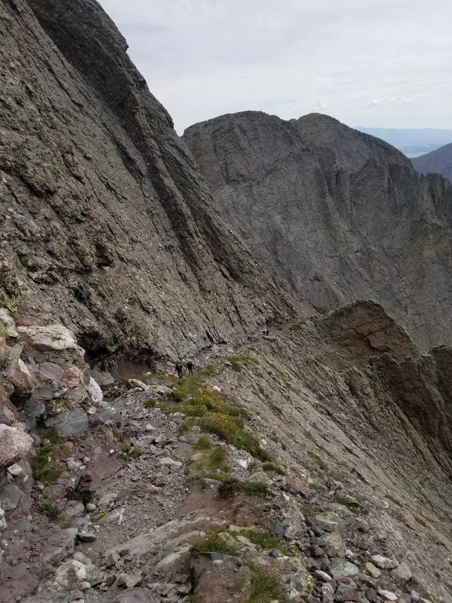
The Kit Carson Catwalk, Sangre de Cristo Range
The GCR is divided into 32 sections, each worthy of a section hike. Given the looped nature of the route, it is essentially endless, and hikers are welcome in travel in any direction and sequence they desire (see FAQ). It is currently sequenced for a counterclockwise thru hike starting at Black Canyon of the Gunnison, though hikers are by no means expected to do the same. Mileages are approximate and will be updated following further scouting.
Table of contents
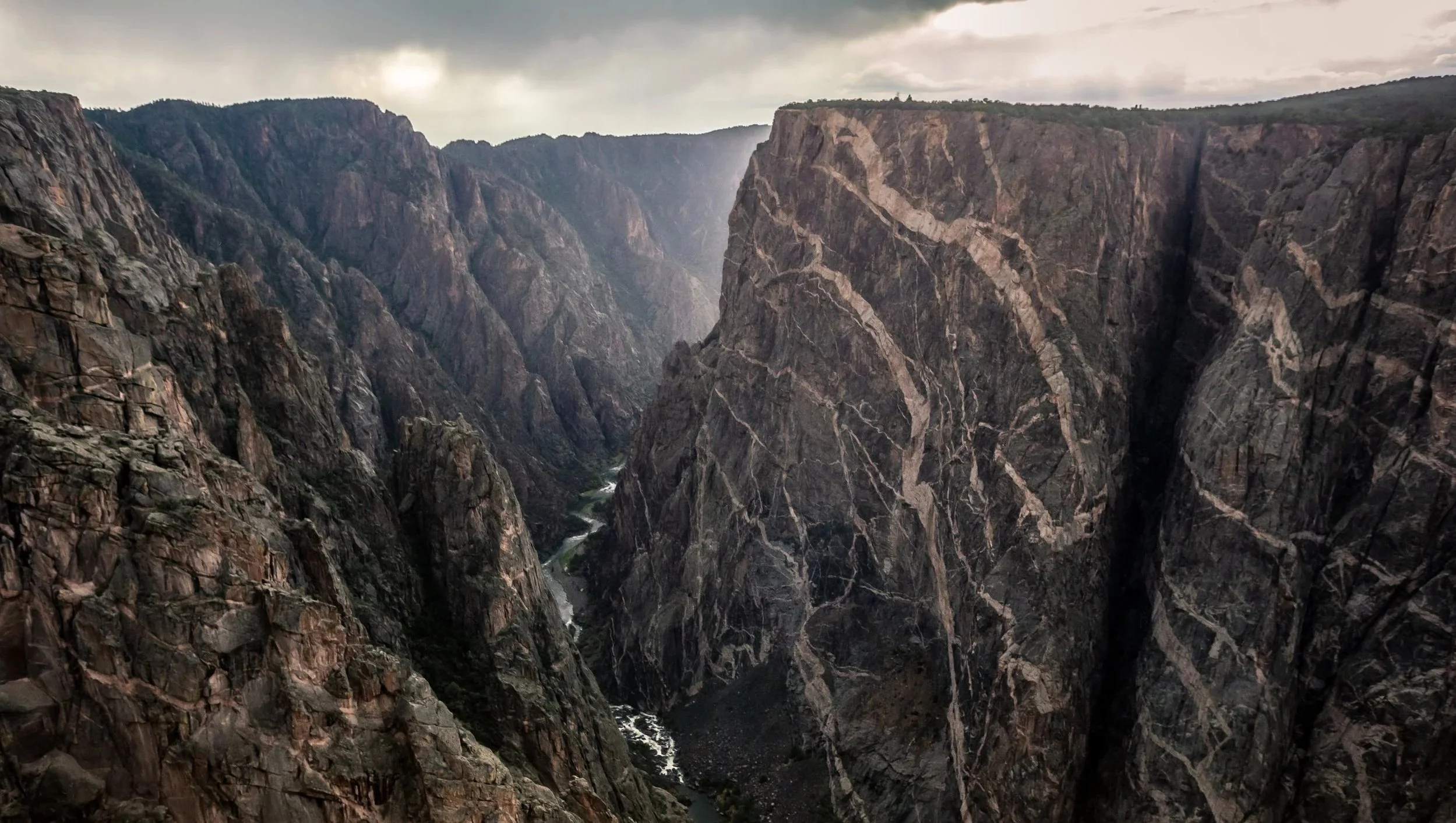
Section 1: Black Canyon of the Gunnison (~38 miles)
The GCR kicks things off with Colorado’s most epic canyon—a national park quite literally split in half due to 2000-foot deep cliffs and an unfordable river at the canyon floor. Though (free) permits can be competitive, a scrambly sidequest down Pinyon Draw is very worthwhile. The GCR traces Black Canyon’s north rim then continues along the Gunnison Gorge. Hikers should be prepared for off-trail travel and scurrying up and down a couple side gullies, as there is no continuous trail along this area. After a quick ford across the North Fork, this section concludes at State Highway 92, providing town access to Hotchkiss to the East and Delta to the West. Those capable of whitewater packrafting may consider rafting the Class III+ Gunnison Gorge then sending their gear home at Delta before reconnecting with the GCR.
Permit and camping information can be reviewed here.
Section 2: Grand Mesa (~60 miles)
From CO-92, the GCR scurries across BLM land to the barren and bone-dry Adobe Badlands. Be sure to check out the area’s iconic Devil’s Thumb. From there, the GCR approaches Grand Mesa (the world’s largest flattop mountain) and traces its western cliffs all the way to Palisade. For hikers uninterested in Western Colorado’s deserts and dazzling canyons, two “super” cutoffs—one through Delta, the other along the American Discovery Trial—are provided (though we encourage folks to give the Western Slope a well-deserved chance).
Section 3: Little Book Cliffs (~41 miles)
North of Palisade are the lovely Little Book Cliffs, a Wilderness Study Area (i.e., BLM-protected land that contains wilderness characteristics but Congress has yet to formally designate as a Wilderness Area). The GCR then drops down to Grand Valley to Colorado’s westermost city, Fruita—only 19 miles from the Utah border! The GCR is considering expanding the trail through Demaree Canyon WSA but for now leaves it for to folks to explore on their own.
Section 4: Colorado National Monument (~55 miles)
Ask yourself if you’re still in Colorado or accidentally crossed into Utah while exploring the Rattlesnake Arches and Colorado’s eponymous National Monument. The GCR serpentines through stunning canyons and arches, though hikers in need of more express routes are provided several alternates. Given the limited options for water, hikers are encouraged to research ahead of time and increase their carry capacity. This section concludes near the East Entrance to Colorado National Monument, providing town access to Grand Junction.
Permit and camping information can be reviewed here.
Section 5: Dominguez Canyon (~79 miles)
Epic canyons continue through this stretch as the GCR joins the Tabaguache Trail before splitting to explore both Big Dominguez and Little Dominguez Canyons. The GCR then takes a cross-country exit through Lightning Basin before coming to a rest at the mouth of Escalante Canyon, providing access to US Highway 50 and the town of Delta to the east. Earlier town access points are available at Whitewater and Bridgeport. An alternate that traverses the Uncompahgre Plateau and reconnects with Section 6 further south is also provided.
Camping information can be reviewed here.
Section 6: Roubideau Canyon (~80 miles)
Wrap up the GCR’s tour of Western Colorado’s colorful canyons with a trek up Roubideau Creek in the Camel Back WSA. After visiting the Ben Lowe Cabin ruins, the GCR enters Uncompahgre National Forest to make its way toward the iconic San Juan Mountains. This section concludes at Buck Canyon along State Highway 62, providing town access to America’s one and only Ridgway without an “e.”
Section 7: Mount Sneffels Wilderness (~37 miles)
After a short connector along CO-62, the GCR makes its grand entrance into the San Juans, starting off with Mount Sneffels Wilderness. Go for a swim in the aptly named Blue Lakes. From there, scale Blue Lakes Pass before following the ridge up Mount Sneffels—the mountain featured on the Colorado Driver’s License. From there, descend Sneffels’ gully to Yankee Boy Basin before taking Virginia Mine Trail and descending to the fairytale town of Telluride. An alternate that goes over Imogene Pass and visits Ingram Falls is also provided. Hikers with rope skills (and gear) may also consider Telluride’s Via Ferrata (guided tours are also available).
Section 8: Lizard Head Wilderness (~78 miles)
From Telluride, the GCR tours the beautiful Ice Lakes Basin before heading towards the San Juans’ most oddly shaped peak—Lizard Head. After passing its base, the GCR gains Navajo Pass near three 14ers, including the one featured on Coors beer cans. A short sidequest up Wilson Peak is doable, though hikers may consider saving their energy for the next task at hand—the El Diente Traverse. From Navajo Basin, the GCR ascends Mount Wilson and follows its scrambly ridgeline to El Diente Peak (a low route is also provided). From there, the GCR descends the Kilpacker Route and makes its way towards Purgatory Flat and US Highway 550 which provides town access to Silverton to the north and Durango to the South.
Section 9: Weminuche High Route (~37 miles)
This section takes you from Purgatory Flat, up the Animas River, to the beautiful Chicago Basin before going off trail for Steve Howe’s epic Weminuche High Route along the Needles Range. Don’t let these unimaginatively named peaks (e.g., Peak 7, Peak 9) distract you. They are some of Colorado’s most magnificent mountains. A low route and bailout options are also provided. The GCR then reconnects with the Colorado Trail and concludes at Stoney Pass. An alternate that walks directly into Silverton is also provided.
Section 10: American Basin (~35 miles)
Enjoy the well-groomed Colorado Trail before splitting for Jones Mountain to reach one of Colorado’s most scenic areas, American Basin. You then summit three of the San Juans’ most approachable 14ers. It concludes with an untrailed ridgewalk and descent to Engineer Pass Road, which provides town access to Lake City. There’s currently no great way to connect these areas without off-trail travel. Alternates are provided, and hikers can also cutoff this and Section 11 by staying on the Colorado Trail.
Section 11: Uncompahgre Wilderness (~32 miles)
Explore the lovely Uncompahgre Wilderness. Though somewhat inefficiently routed, the GCR’s route provides better views than the shorter option. You also have the option for two quick sidequests up Wetterhorn and Uncompahgre Peaks. This section ends at Independence Gulch Trailhead which provides access to the hiker friendly town of Lake City.
Section 12: La Garita Wilderness (~81 miles)
This lengthy and demanding section starts by exploring the oft-forgotten Powederhorn Wilderness before making its way towards La Garita Wilderness. It then goes on an extended ridgewalk (low route also provided) up and over San Luis Peak towards Wheeler Geologic Area, a former National Monument. The GCR then walks through the small town of South Fork which has resupply and lodging options. An alternate that shoots directly across the San Luis Valley through Center and Hooper is also provided, but hikers will likely prefer the logistically simpler main route for Section 13. Hikers wishing to add considerably more miles may also consider creating a custom route that links up with the CDT southbound to experience the South San Juan Wilderness before reconnecting to the GCR.
Section 13: Bennett Peak (~77 miles)
From South Fork, the GCR joins mountain biking trails up and over Bennett Peak in the Rio Grande Forest. It then drops to the San Luis Valley (the world’s largest alpine valley) near the Monte Vista Wildlife Refuge before walking into the city of Alamosa which has ample resupply and lodging options. Please be careful with road traffic and respectful of private property.
Camping information can be reviewed here.
Section 14: Sangre de Cristo High Route (~104 miles)
From Alamosa, the GCR makes it way towards Lake Como, the access point to a cluster of 14ers. The main route gains Ellingwood Point (with easy access to Blanca Peak) before descending to South Zapata Creek. Be sure to visit Zapata Falls on your way towrads Great Sand Dunes National Park. Load up on water at the visitor center then trek across the most unique terrain of the GCR, the dunes. Stargaze in one of the least polluted skies in all of Colorado. Then make your way up Sandy Creek Trail where the GCR joins Justin Simoni’s Sangre de Cristo Range High Route. Low route options are provided, including town access to the small community of Crestone (which divides the food carry roughly in half). The GCR then exits via the Rita Alto Loop and concludes at the quaint town of Westcliffe in the Wet Mountain Valley.
Permit and camping information can be reviewed here.
Section 15: Grape Creek (~36 miles)
It was recently brought to our attention that the intended access point for Upper Creek WSA out of Westcliffe might be inaccessible due to private property. We are investigating solutions. More info can be found here.
Prepare for wet feet as you make your way along Upper and Lower Grape Creek Wilderness Study Areas. In the future, GCR hopes to secure permission for hikers to enter the Royal Gorge Bridge from the West entrance so hikers may experience North America’s largest suspension bridge with its stunning views of the 1000-foot deep gorge. This aspirational route is provided, but hikers need to understand it is currently unauthorized. Hikers may consider instead taking a sidequest to either raft down the Royal Gorge with any of the local outfitters (Whitewater Adventure Outfitters is strongly recommended given how hiker friendly they are. They might even provide shuttling and camping for a nominal fee) or take the Royal Gorge Train.
Section 16: Phantom Canyon (~34 miles)
The GCR then makes it way towards the town of Victor. Currently the most sensible route is via Phantom Canyon Road. Two aspirational routes are provided as untested alternates that may prove unnavigable or unworthwhile. The first alternate takes you up Beaver Creek to the abandoned Skaguay Power Plant, a hidden backpacking gem with beautiful cliffs. It remains unproven whether the creek south of the power plant is traversable. The second alternate involves cross-country travel across the Beaver Creek WSA toward the Penrose-Rosemont Reservoir. It is currently unknown whether this off-trail option provides adequate views to be worth the extra effort.
Section 17: Pikes Peak (~61 miles)
The GCR connects Victor to Manitou Springs before embarking on a true right of passage for any Coloradan—the Manitou Incline. Hikers may consider first doing a short sidequest through Garden of the Gods. After the Incline, hikers make their way up the Barr Trail to the summit of Pikes Peak (perhaps spending a night at the A-frame shelter along the way and rewarding themselves with a famous Pikes Peak donut at the summit). The GCR then descends the west face of Pikes and connects to the unincorporated town of Divide. Hikers not wanting to do the infamous incline are provided two alternates.
Permit and camping information can be reviewed here.
Section 18: Lost Creek Wilderness (~73 miles)
Trek across the lovely Lost Creek Wilderness with its famously bizarre boulders. Hikers are encouraged to explore the peculiar summit of Bison Mountain. Some slightly shorter alternates are also provided. After crossing the Colorado Trail, this section reaches the town of Bailey. Those wanting to bypass Sections 19 and 20 can alternatively follow the Colorado Trail southbound till Georgia Pass.
Section 19: Mount Blue Sky Wilderness (~28 miles)
From Bailey, the GCR then makes it to the Mount Blue Sky Wilderness (note: the wilderness area’s official name has yet to be updated despite the eponymous peak being renamed…). Upon reaching the summit of Mount Blue Sky, the GCR takes the visually imposing Sawtooth Traverse to Mount Bierstadt before descending to Guanella Pass which provides town access to Georgetown to the north (recommended) and Grant to the south. Multiple alternates are provided for different comfort levels with regard to scrambling and exposure.
Section 20: Front Range (~36 miles)
After gaining Square Top Mountain, the GCR follows the CDT southbound along one of its more iconic ridgewalks along multiple Front Range 13ers till Georgia Pass. From there, the main line continues following the ridge until Red Mountain before descending to Quandary Peak Trailhead which provides town access to Breckenridge to the north and Alma to the south. This portion and Section 21 can be bypassed by continuing along the Colorado Trail into Breckenridge. Alternatively, hikers in need of easier terrain can take the CDT northbound, bypassing GCR Sections 20-23 (and thereby missing several of the GCR’s most memorable parts).
Section 21: Tenmile Traverse (~20 miles)
Make plenty of new friends while climbing Quandary Peak before descending towards McCullough Gulch. From there, the GCR regains the ridge and takes the famous Tenmile Traverse across America’s youngest National Monument: Camp Hale—Continental Divide. The traverse involves some scrambly sections near Peaks 3 and 4 before descending to the town of Frisco. A trailed alternate is provided and reconnects with Section 22 after swinging by Copper Ski Resort.
Section 22: Gore High Route (~48 miles)
Prepare to have your socks knocked off by the dramatic Gore Range (aka the Naa Ohn Kara) in the Eagles Nest Wilderness. Given the lack of trailed passes, the GCR instead takes a custom high route along the jagged peaks while trying to avoid the Class V (i.e., climbing) terrain along the ridgeline (for those interested, consider the Naa Ohn Kara Traverse). Hikers should exercise extreme caution if attempting this high route. It is currently unproven and may be unnavigable, dangerous, and deadly. The gpx track is approximate, unverified, and is not a suitable replacement for route-finding. Several bailouts and two low routes are provided. The section ends at Harrigan Creek Trailhead, providing town access to Silverthorne to the south and Kremling to the north.
Section 23: Saint Louis Divide (~39 miles)
The GCR gives some of the states most majestic 12,000-foot peaks the love they deserve by scaling Ute Peak before linking up with the Saint Louis Divide Trail. You then reconnect with the CDT and follow it to Berthoud Pass which provides town access to Winter Park to the north (recommended) and Empire to the south. An alternate route that walks directly into Winter Park is also provided, bypassing the James Peak Wilderness in Section 24.
Section 24: Indian Peaks (~81 miles)
Welcome to the (bypassable) crux of the GCR: a Pfiffner’s Traverse—LA Freeway hybrid. From Berthoud Pass you follow the ridge from Flora to James Peak and continue along the CDT until Devil’s Thumb. From there, the GCR takes Andrew Skurka’s version of Pfiffners Traverse (Class 3 scrambling) to visit one of Colorado’s most photogenic destinations: Crystal Lake and Lone Eagle Peak. After regaining the Divide, the GCR joins Buzz Burrell’s sardonically-named LA Freeway. While singing 🎵 If I can just get off of this LA freeway without gettin’ killed or caught 🎵, you bypass two Class V sections by descending a gully around The Cleaver and traversing an exposed ledge on Pagoda Mountain. Multiple alternates and bailouts are provided for those uncomfortable with these demanding sections. After gaining Longs, arguably Coloraodo’s most famous 14er, the GCR takes the iconic Keyhole route down before doing a brief tour of Rocky Mountain National Park’s more scenic areas. The section ends in Estes Park, a popular tourist town.
Given how strictly regulated this area is, we strongly recommend you check out permit, camping, and suggestive itinerary information here.
Section 25: Rawah Wilderness (~86 miles)
After a brief connector from Estes, the GCR joins the NOCO Trail—Northern Colorado’s premier thru hiking trail. This section explores the oft-overlooked Comanche Peak Wilderness and Rawah Wilderness (have fun asking locals how to pronounce it). The views are spectacular. This section concludes at the eastern edge of Walden Valley.
Permit and camping information can be reviewed here.
Section 26: Walden Valley (~33 miles)
Explore Walden Valley, San Luis’s northern twin. The GCR continues along the NOCO Trail along roads, including a town stop in Walden. Hikers may be relieved to discover that Walden Valley contains several parcels of BLM land where one can camp with fewer difficulties.
Camping information can be reviewed here.
Section 27: Mount Zirkel Wilderness (~46 miles)
Explore Big Agnes’s backyard in the Mount Zirkel Wilderness. The GCR continues along the NOCO Trail which joins the Wyoming Trail (also host to the CDT). Cruise along lovely mountains till Rabbit Ears Pass, which provides town access to Steamboat Springs. Those seeking extra adventure are encouraged to take the Mount Zirkel and Big Agnes Mountain alternate that summits these northern beauts.
Section 28: Sarvis Creek Wilderness (~58 miles)
Say goodbye to the CDT and continue along the NOCO in the quiet and less-traveled Sarvis Creek Wilderness. Enjoy the solitude of the southern Park Range before connecting to the mountain town of Yampa. An alternate that visits the hiker-friendly community of Oak Creek is also provided.
Permit and camping information can be reviewed here.
Section 29: Flat Tops Wilderness (~94 miles)
The GCR then explores one of Colorado’s most slept-on and unique subranges—The Flat Tops. These peculiar plateaus host the NOCO’s most iconic destination—The Devil’s Causeway, a stunning catwalk with dramatic cliffs on both sides. The GCR finishes out the NOCO through the White River Plateau before saying goodbye at the tourist town of Glenwood Springs.
Section 30: Maroon Bells—Snowmass Wilderness (~78 miles).
After a brief connector along the paved Rio Grande Trial and passing by the town of Carbondale, the GCR heads into Colorado’s most photographed area—The Elk Range. The GCR makes it way to the striking Capitol Lake with its stunning view of Capitol Peak’s northern face before joining the famous Four Pass Loop in the Maroon Bells—Snowmass Wilderness. Peak baggers and high route aficionados may consider tacking on extra challenges and custom routes through this epic playground (though be warned the rocks in this range are famously unstable and multiple deaths have resulted from poor decision-making and bad luck). Those wishing to visit Aspen may consider taking a shuttle from Maroon Lake. Otherwise the trail continues till Schofield Pass, providing access the scenic ski town, Crested Butte.
Permit and camping information can be reviewed here.
Section 31: Ruby Range Traverse (~22 miles)
We were recently made aware that there is a public access dispute downhill from Green Lake, so hikers are encouraged to exit the traverse via Scarp Ridge Trail.
From Yule Pass, hikers are presented two options for the Raggeds Wilderness, a high route along the Ruby Range Traverse and a low route that serpentines across it. The Ruby Range Traverse is an iconic ridgewalk worthy of a standalone adventure. The trailed low route still provides ample views, including both Daisy Pass and Oh-Be-Joyful Pass. This small but mighty section ends at Horse Ranch Park, providing town access to Crested Butte. An alternate that walks directly into Crested Butte and reconnects further south along Section 32 is also provided.
Section 32: West Elk Wilderness (~63 miles)
Gatekeeping nothing, the GCR showcases one of Colorado’s most slept-on wilderness areas—The West Elks. Take in the stunning Castles and everything else this quiet area has to offer. After West Elk Peak, you are unlikely to encounter many other hikers beyond the occasional hunter or equestrian. This section concludes at the town of Crawford.